Mr. Nolde's Sixth Grade
Page
|
Many of
the activities linked on this page still use Flash.
At this point in
time, my best suggestion is to use Chrome browser. When doing so, be
sure to add the RUFFLE extension.
You can download that extension by going to this site.
HTML5
activities are being posted here as more of them become available on the
world wide web.
|
If a site uses flash, you will see this symbol next to the link:
 |
|
If a site uses HTML5, you will see this symbol next to the link:

|
|
The Earth & Its Materials |
Name That Rock! -This game will
help you to study for our lab practical on some of the most common types of
rocks found on Earth.
The 15 Most Wanted
Quiz Game! -This game will
also help you to study for our lab practical on some of the most common types of
rocks found on Earth.
Online
Lab Practical -This page contains
pictures of some of our most common rocks in the world. On a separate
piece of paper, see if you can correctly identify each one of the rocks.
Here's
a Second Online
Lab Practical! -This page also contains
pictures of some of our most common rocks in the world. On a separate
piece of paper, see if you can correctly identify each one of the rocks.
Minerals and
Metals Around the House -Did you ever stop and
think about just how many raw materials are used in all of the things that we
have in our house? This game helps you discover just some of the many
minerals and metals that are used in making the many things that we take for
granted.
 Drag
& Drop Rock Cycle Chart -This activity will help
you review all of the basic processes that happen throughout the course of the
rock cycle. See if you can correctly place each label into this rock cycle
chart.
Drag
& Drop Rock Cycle Chart -This activity will help
you review all of the basic processes that happen throughout the course of the
rock cycle. See if you can correctly place each label into this rock cycle
chart.
Layers of the
Earth -This site does a great job of quickly
explaining the three basic layers of the Earth.
Mohs' Drill & Castle
of Doom! -Learn about Mohs Mineral Hardness Scale while escaping the Castle of
Doom! The walls are closing in on you. To escape, you must drill through the
walls. See if you can find the right drill to blast through the wall.
How
do Diamonds Form? -This is a question that I often
get asked. This page has a great animation that does a good job of
explaining the process that can turn carbon into a diamond.
Top of
Page
Soil
Composting -Plants need soil that is enriched with
nutrients. You can help enrich the soil by composting. In this
activity, decide which items get recycled, and which items need to be put in the
composting bin.
Test Your
Soil IQ -Let's see just how well you understand the
basics of soil and why soil is so very important to us. See if you are a
soil expert by getting all 8 questions correct in this activity.
"The
Dirt on Soil"- Soil Safari -Get ready to take the
pilot's seat of the Earth Ship as you travel on a microscopic safari through the
soil beneath your feet! Your help is desperately needed in this area where
a toxic chemical is making its way through to the underground water. Your job
is to discover what kind of soil organism can actually eat this
toxic chemical. Can you find this organism in time to save the meadow?
Let the adventures begin!
Soils
Around the World -Did you ever stop to think about
the fact that soil is NOT the same everywhere in the world? Depending on
the type of climate & topography, soil varies from place to place. For
example, the type of soil that you will find in a tropical rainforest will be
quite different from a soil that you might find in a desert or in an polar
region. This activity has a really good interactive map that lets you
explore the various soils of the world.
Map of NJ
Showing Average Annual Precipitation -This map
will help you with the last step of our lab examining how soil varies from place
to place.
Profile of NJ's State
Soil -This site has a picture of a typical soil
profile from the state of NJ that will help you with the last step of our lab
examining how soil varies from place to place.
Dirt Detective: Trees & Soils -This activity helps
us to understand what soil scientists do. Perform two tests on the soil samples
to learn why you find different trees growing in different environments.
As you do this activity, think about which soil type is most similar to the soil
that we find in Edgar woods!
Which Types of Soils Absorb Water the Fastest?
-See if you can correctly predict which soil type: gravel, sand, or silt will
absorb water the fastest. Be sure to click the red "off" button at the exact
time in which the water gets completely absorbed by the soil type!
Top of Page
|
Landforms, Weathering, & Erosion |
Shape
it Up!
-In class, we explored how the Grand Canyon was formed by the powerful eroding
force of water. This activity explores how wind, water, volcanoes, and
glaciers have had an impact on the shape of our land over time. Be sure to
play this game more than once! Although you might get the same landform
with the same erosional force, it might be showing you a different length of
time!
 Types
of Mass Movement -As we discovered when working
with our stream tables, gravity has a huge impact on the movement of
sediments. In this activity, be sure to read the overview first. Then
click on the overview tab. There are 8 slides for you to check out before
going over to the interactive model.
Types
of Mass Movement -As we discovered when working
with our stream tables, gravity has a huge impact on the movement of
sediments. In this activity, be sure to read the overview first. Then
click on the overview tab. There are 8 slides for you to check out before
going over to the interactive model.
Where
do Sediments get Deposited by a River? -This is
another animation that will help you to visualize why certain sized
sediments get deposited where
they do.
How do Sinkholes Form? -Do you remember what
we learned about chemical erosion? This activity really helps explain how
caverns and sinkholes form under the ground.
Groundwater Adventure
-Be sure to check out this interactive adventure that will help to understand and see groundwater, sinking streams, rock
and other features in the structure of karst.
The
Water Cycle Explained -Click on the various
parts of this interactive to learn more about all of the processes that are
involved in the water cycle.
Water
Cycle Diagram -Click on the various parts of
this interactive diagram to learn more about all of the processes that are involved in
the water cycle.
Water
Cycle Game -This activity is a great way to
learn about and remember all of the important parts of the water cycle.
Top of
Page
Oceans and Continents Quiz Game -See if you
can get a perfect score of 33 by correctly identifying all seven continents and
four of the five oceans in this game.
Oceans
& Continents ID Game -Click on the correct
continent or ocean in this quiz game. See if you can get a perfect score
of 11 points in the shortest amount of time!
Oceans
& Continents Advanced ID Game -In this quiz game,
you will need to click and drag the continent or ocean to the correct spot on
this map. See if you can get a perfect score of 11 points in the
shortest amount of time!
Fifty Nifty United
States Quiz Game -See if you can get a perfect
score of 50 out of 50 by correctly identifying the location of all fifty states of
the U.S.A. in this game.
Place
the State -This game is a bit trickier to play
than the Fifty Nifty United States Quiz Game. In this game, see if you can
correctly place each state in its EXACT place on the map.
Top of Page
Rockman's Geological
Time Chart -This site does an excellent job of describing and displaying all of
the different geological time periods. Also, be sure to check out Rockman's
rock cycle page.
Fossil
Fun!- Burying Bodies -A lot about what we have learned about the Earth's history comes from its
fossil record. This activity helps you understand what are the perfect
conditions in order for a fossil to be formed. Click and drag the dead
beast in this activity and place it in different parts of the picture to see
what happens!
Making
Fossils -A once living organism must go on a
lengthy journey before it can reappear at the surface as a fossil. It's
very rare that all the conditions are right for this strange process to
happen. This website does a very nice job of giving you an overview of the
types of fossils and how they form.
Layers
of Time! -This is a really cool game. Using
the fossils found in each layer of rock, see if you can correctly place the rock
layers in order from the oldest layer (being on the bottom) to youngest layer
(being on the top.) When doing this activity, be sure to use the fossil
clues in each layer to help you match layers of rock that belong together.
Grand
Canyon Explorer -This site does an awesome job of
explaining a lot of the common questions that students have about the Grand
Canyon.... How did it form? Where did all of the rock come from? Why
does it look like it does? When did all of this happen?
Photos
from the Grand Canyon -Did you enjoy seeing Mr.
Nolde's photos from his rafting trip down the Grand Canyon? The National
Park Service has posted LOTS of great photos to enjoy.
Click on any of the thumbnails for larger pictures.
Top of Page
Plates
on the Move -Explore 12 different places around
the world and learn how the movement of our tectonic plates has affected these
areas in very different ways!
World
Plates & Boundaries Flash Map -This flash map
allows you to quickly see where the largest of the tectonic plates are located
and allows you to animate their size and their boundary outlines.
How
Continental Plates Move:
|
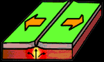
Divergent Boundaries |
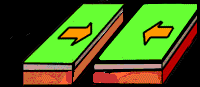
Convergent Boundaries |
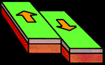
Transform Boundaries |
Interactive
World Map -This interactive map allows you to
display where the various types of plate boundaries are located throughout the
world.
Sea Floor
Spreading Animation -This flash animation does a
fine job of illustrating what happens at divergent boundaries on the ocean
floor.
Formation of Ocean Crust -This flash animation
gives a good visualization of how new ocean crust forms.
Animation
of Convection Currents -As we discovered in class,
scientists believe that the continents are slowing moving due to the convection
currents that are moving in the semi-liquid mantle below the Earth's crust.
This animation does a nice job illustrating this movement.
Convection
Currents in a Heated Container of Water -When
water boils, it's basically convection currents going at full tilt!! This
animation gives us a good visualization of what's really happening at the
molecular level. Be sure to click on the bunsen burner to heat up the
liquid.
Mr.
Nolde's Convection Demonstrations -Why do
continental plates move? What causes earthquakes? What causes mountains to
form? What causes wind? How does a hot air balloon work? Why
is my attic much hotter than my basement? In my humble opinion, I believe that
the concept of convection is one of the top 10 important scientific concepts for
people to understand when figuring out how things in the world work! On
this page are a collection of convection demonstrations that I recorded to video
many years ago. They are not the highest of video quality, but they still
are an interesting exploration on the concept of convection!
Pangaea Flash
Animation -This flash animation shows Alfred
Wegener's theory of continental drift.
Interactive
Time Travel Earth Model! -Have you ever wondererd
what the Earth's land features looked like at different time periods? This
amazing 3-D model allows you to enter a specific city in the world. Enter in the
town or city that you live in. It will place a red pin on the globe for that
location. You will be able to see where you lived looked like over time.
You can either use the top menu to select a time period, but more interesting
than that, is the "Jump To" menu on the right top corner of the screen that
allows you to select different life and geological events. Also, be sure
to try out different display options as well. Very cool, if I may say so myself!
Top
of Page
Animations of Earthquake Waves:
Primary
Waves -This simple animation shows you what primay
waves (also called P-waves) look like during an earthquake. Primary waves are
the first seismic waves to arrive at a location during an earthquake. They are
the fastest seismic waves and can travel through solids, liquids, and gases.
Primary waves alternately compress and stretch the rock through which they pass.
Secondary
Waves -This simple animation shows you what
secondary waves (also called S-waves) look like during an earthquake. Secondary
waves are the seismic waves that move through the Earth after an earthquake,
shaking the ground back and forth. They move more slowly than P-waves, but cause
the most intense shaking and damage during an earthquake.
Earthquake
Simulator -There are a number of factors that have
an effect on the magnitude of an earthquake. In this simulator, experiment
by adjusting the length of the fault, the depth of the earthquake, the length of
how far the fault shifted, and the rigidity of the rockbed.
Build
an Earthquake Resistant House
-This activity actually lets you design homes that are resistant
to more than just earthquakes. You can also design houses that are
resistant to floods or hurricanes as well. If working on designing an
earthquake resistant home, be sure to click on that part of the map to start
your engineering adventure!
The Hot Zones -This is another site that explores
how plate movement causes earthquakes, volcanoes, and mountains to form.
There are a number of really good animations in this site to help explain these
wonders of the Earth.
Earthquake Fault Animations:
Earthquake Animation -What happens inside
the Earth when an earthquake happens? Click here to find out.
This site has
some good animations that help us to better understand earthquakes.
Earth: All Stressed
Out -This step-by-step exploration of what happens
during an earthquake features a number of great animations to help us better
understand just what goes on during an earthquake.
Top of Page
Top
Earthquake States -Which states rank in the top
ten for earthquakes? Click here to find out.
Latest
Earthquakes in the USA -This site
has really great, detailed map of the latest earthquakes that have happened in
the U.S. Be sure to click on parts of the map to zoom in! You can also
zoom out to see where earthquakes have recently taken place in the rest of the
world.
Significant
Earthquakes by Year -Are you curious what
significant earthquakes happened during the year you were born? Select a
particular year using the dropdown menu and you will get a list of most
significant earthquakes that happened during that year. Click on any of
the earthquake sites to learn more about each earthquake.
List of Earthquake Times &
Locations -This site gives you a concise listing
in chronological order of the latest earthquakes over 2.5 and their locations.
Make sure that you move the map around to see the latest Earthquakes for that
particular region.
EDGAR SCHOOL
Earthquake Research:
The files below require Adobe Reader.
Click here to
get your free copy of Adobe Reader

Mr.
Nolde's 2004-2005 Earthquake Journal -Click here to see
our first-ever Edgar School Earthquake Journal! Do you notice any patterns as to where the major
earthquakes in the world tend to take place?
Mr.
Nolde's 2005-2006 Earthquake Journal -Click here
to see our second Edgar School Earthquake Journal. Do you notice any
similarity in the patterns as to where the major earthquakes in the world took
place in this year's journal compared to our previous journal?
Mr.
Nolde's 2006-2007 Earthquake Journal -Click here
to see our third Edgar School Earthquake Journal. Do you notice any
similarities or differences in the patterns as to where the major earthquakes in the world took
place in this year's journal as compared to our previous journals?
Mr.
Nolde's 2007-2008 Earthquake Journal -Click here
to see last year's Edgar School Earthquake Journal. Looking at all of our
earlier data, do you find any patterns emerging?
Mr.
Nolde's Compiled Classroom Earthquake Journals
-This map is the work of ongoing research that Mr. Nolde's students have
collected using data from the
USGS website. Click here to see what the world map looks like with ALL
of the earthquakes that Mr. Nolde's students have plotted over the past 4 years!
Do you notice any distinct patterns as to where the major earthquakes in the
world take place? Why do you think so??
Top
of Page
Volcanoes
& Earthquakes
of the World -This interactive map shows you where
the most recent volcanic and earthquake activity is taking place in the world.
Global
Earthquakes and Volcanoes Map -This interactive
map allows to highlight where active volcanoes and recent earthquake activity is
located around the world.
Volcano Animation -This site gives us a good view
of what happens inside a volcano when it erupts.
Potentially Active Volcanoes
in the U.S.A. -This interactive map lets you
discover and explore where the most likely to erupt volcanoes are located in the
United States. Move your mouse over each volcano site and see a picture of what
each one looks like!
Visit
a Volcano- Cascade Range Volcanoes -This is
another interactive map that focuses on the volcanoes all along the west coast
of Washington, Oregon, & northern California.
Mount
Saint Helens VolcanoCam -Where else can you see
what's going on with Mount Saint Helens? Right here on Mr. Nolde's sixth
grade page of course! This web cam gives you live images of this active
volcano.
Animation
of Volcanic Eruption at a Subduction Zone -This
site does a fairly good job of simply animating what goes on at a subduction
zone. Be sure to continue to press the play button to see the next
part of the animation!
How did the Hawaiian Islands Form? -As you might
know, Hawaii's Islands have all been formed by volcanic activity. But did
you know why Hawaii is a string of islands? This site does an excellent
job of demonstrating how the Pacific plate is gradually moving across a hot spot
below the lithosphere and how that has formed this string of islands.
Animation
of a Hot-Spot -This site also has a great
illustration of how hot-spots create a chain of volcanic islands like we have in
Hawaii.
Top of Page
Phases of the Moon -This flash animation is
one of my favorites out there showing the phases of the Moon!
Moon
Phases Simulator -This animation also does a great
job of showing the phases of the moon relative to where the Moon is in
relationship to the Earth and the Sun.
Moon
Phases Interactive -This site does an excellent
job in helping you understand why we see the moon only at certain times of the
day depending on what phase that the moon is in. Be sure to click on the
tab that says "introduction" to get a better understanding as to how the
interactive works.
Phases of the Moon from Earth and Space
-What's nice about this animation is the fact that you can switch back and forth
between views from above (North Pole) and views from the side (oblique view)
while at the same time, see what the moon looks like from Earth.
Eclipses
and Moon Phases -Be sure to check out both MODES
of this activity: Eclipses & Moon Phases. When you check out the
Eclipse Mode, be sure to click on your different choices in the View From
box! Also, be sure to slide the Top View- Side View slider as well!
COOL!!
Moon Phases Gizmo -The Moon phases gizmo actually
lets you set how fast the phases of the Moon and the rotation of the Earth take
place.
Why
do we always see the same side of the Moon? -As
you've been carefully observing the Moon during your moon journaling, you've
probably noticed that you are always seeing the same surface of the Moon.
If you don't believe me, use a pair of binoculars each night and you'll notice
that you are always seeing the same craters! Anyhow, in addition to my
coffee cup model that we do in class, this website does a good job of
demonstrating why we always see the same side of the Moon.
What did the moon look like on the
day you were born? -Just enter in whatever time
and date that you wish, and you can see what the moon looked like on that
particular day. Pretty cool...eh?
How much do I
weigh on the Moon? -Go to the weighing station to
find out! As you learned in class, gravity is the force that
pulls things towards the center of the Earth. When we weigh something, we
are actually measuring this force! Your bodyweight will be different, depending
on what planet you're standing on!
Sky Watching
-This is a great website that has tons of cool articles about what to look for
in our sky over the course of the year. In particular, I like some of the
photographs that they include in their articles.
The
Sky at a Glance -This is another great site that
gives you fascinating information about what you may find in the sky on a clear
night. This site usually has a good diagram or two of the evening sky
which you might find to be very useful.
How
Much Light Pollution is in Our Sky? -This site
will give you a great idea as to how much light pollution there is in our area.
It will also give you a little bit different perspective of the night sky
depending upon what latitude you place yourself in the world. If you move
the other slider closer towards the street light, you will see how much
more of the night sky that you are missing out on! The constellation in
this activity is the constellaion of Orion. Here's
a link to help
you find the constellation Orion in our night sky.
Moon Phases Calendar
-This lunar calendar comes from the Old Farmer's Almanac website. It shows
you what phase the moon is currently in and what the moon should look like for
the rest of the month as well.
Mr. Nolde's 2005 Moon Journal
-
This was the first time that I put my photos into a flash
presentation... enjoy!
Mr. Nolde's 2006 Moon Journal -
Here is next year's moon journal. Are there any
similarities or differences with 2005's moon journal? Be sure to
check out the page that has all of the still pictures from this slide
show as well.
Mr. Nolde's 2007 Moon Journal -
Here is 2007's year's moon
journal. Be sure to check out the page that has all of the still
pictures from this slide show as well.
Mr. Nolde's 2008 Moon Journal -
Here is my moon journal
from the next year. What makes this moon so different from the
earlier ones??
Mr. Nolde's 2009 Moon Journal -
Here is my moon journal from 2009.
Mr. Nolde's 2010 Moon Journal -
And finally.......the last moon journal
that I photo-documented. Six years of doing so was an AMAZING
experience. I hope that you enjoy them all!
Mr. Nolde's
Pictures from the Nov. 8th 2003 Lunar Eclipse -As
we learned in class, eclipses of the moon are more commonly seen. If you
ever get a chance to witness a lunar eclipse, I highly recommend documenting its
progress with a digital camera just like I did!
Mr. Nolde's
Pictures from the Oct. 27th 2004 Lunar Eclipse
-Here is my second attempt at documenting a lunar eclipse. This time, I
was able to do some more experimenting with the shutter speed to capture more of
the red & orange colors when the moon was completely eclipsed by the Earth.
Mr.
Nolde's Slide Show of the February 20th, 2008
Lunar Eclipse
-Here is my third attempt at documenting a lunar eclipse. Again, I was
able to do some more experimenting with the shutter speed to capture more of the
red & orange colors when the moon was completely eclipsed by the Earth.
What
Causes a Solar Eclipse?
-In class we discovered what causes a solar eclipse. This website does a
good job of explaining this phenomena.
Solar Eclipse Animations -Did you know that there
are actually three types of solar eclipses? Click here to see animations
of all three types of solar eclipses.
Why Do We Have Tides? -The gravitational pull
of both the Sun and the Moon have a tremendous effect on the oceans of our
planet. This animation does a great job of showing just how the Sun and the
Moon have different effects on the oceans at different times during the Moon's
revolution around the Earth.
Why
is there 2 Bulges? -Some of you were asking in
class why there are 2 bulges of the ocean- one on the side closest to the Moon
and one on the opposite side of the Earth. This site does a great job
explaining why this phenomenon occurs.
Why Does the Size of the Sun Appear to Change?
-This investigation allows you to figure out just how far the Earth is from the
Sun at different times of the year. Once you calculate the Earth's
distances for each month, you get to see what the Earth's actual orbit looks
like!
What is the Reason
for the Seasons? -Did you ever wonder why we have
winter and summer when we do? Did you realize that half of the world is
experiencing summer, while we're experiencing winter? This site helps reinforce
some of the ideas that we will explore in class.
Interactive
Season Animation -This animation allows you to
view the Earth as seen from the Sun. Also, be sure to move the slider from
"side view" to "top view" to get a different perspective as to why we have
seasons.
Name
the Planets -Do you know your solar
system? Warm up with this activity! Click and drag the
correct name over the correct picture. This activity came out a long time
ago! How do I know that?? Well... scientists don't even consider Pluto to
be a "planet" anymore. Due to its small size, we now consider Pluto to be
a dwarf planet.
Explore
the Solar System
-Click on the planets and other items of interest found in our solar
system to learn more about each.
Design
a Planet -This activity lets you design your very
own planet. You get to choose what kind of star it orbits around, whether
or not it has volcanoes, whether or not it has water, and so much more!
Top of Page
Is the Glass Half-Empty or Half-Full? -This
film does a really good job in examining where we are and what we need to do in
the world today. If nothing else, this film will make you think more deeply
about this question!
Groundwater Adventure
- Be sure to check out this interactive adventure that will help to understand
and see groundwater, sinking streams, rock and other features that make up the
ground that we live on. Be sure to click on the non point source pollution
link as well!
What's Wrong with this Picture? -See if you
can correctly identify all of the human activities in this picture that are
polluting our groundwater.
PowerPoint
Presentation on our Non Point Source Pollution Lab
-Click here to view the PowerPoint presentation that was used during our
groundwater pollution investigation. (You need to have PowerPoint to
correctly view this file!)
Animation of a
Watershed -This is a great animation that helps
you visualize how water drains in a watershed. Just click on the play
button to start the animation.
You are the Solution to the Pollution! -When
you think about it, you are the solution to the pollution. This is another
great site that identifies non-point sources that pollute our drinking water.
100
Ways to Save Water! -We know that one way to save energy is
to reduce the amount of water that we use in our homes. This website does
a great job of giving you 100 different ideas of how you can save
water.
Water-Use
it Wisely Concentration Game -This is a fun game of
concentration that teaches us about great ways to reduce our water consumption.
Take
the Water Conservation Challenge -Imagine if everyone of us
pledged to reduce our water consumption by ten gallons a day! I challenge
YOU to take the Water Conservation Challenge!
Air Pollution & Acid Lakes -What happens
when factories and cars put too much chemical pollution into our air? It
pollutes our clouds, which then pollutes our ponds, rivers, streams, and
underground water supplies when it comes down as acid rain. Find out just how
bad acid rain can be to all of the plants and animals that live in this water by
playing this activity.
Oil & Water Don't Mix! -Did you ever wonder
how oil spills are cleaned up? Be sure to check out this activity to learn
just how they do it.
Animation of the Greenhouse Effect -This site does
a great job of animating and explaining exactly what it is that is causing a
trend in global warming.
The Dumptown Game
-You are Dumptown's new
City Manager. When you start to play, you'll see Dumptown at its worst — it's
littered, polluted, and nothing is being recycled or reused. There are many
trash cans and dumpsters, but no recycling bins. That means all of the trash is
going right into the landfill just outside town, where it isn't doing anyone any
good. In your new position, you can start programs that encourage Dumptown's
citizens and businesses to recycle and reduce waste.
Grocery
Store Wars -This is a funny video with a serious
message about choosing organic produce over cheaper produce that has been grown
using pesticides. Remember... every choice that you make DOES make a
difference!
Famous Geologists Page
Careers in Earth Science
Top of Page